We looked high and low to put together some of the most dangerous roads in the world. Whether in the mountains, along the coast or through crowded cities these killer highways will make you appreciate that rush-hour traffic or road-construction detour. Narrow, precarious and poorly maintained, some of these roads are still very much worth the drive. They ascend steep mountain sides and traverse large stretches of wilderness. Often, they're the only option for people to travel in the area.
Karakoram Highway - China to Pakistan

Many of the most dangerous roads in the world can be found high in the mountains. It makes sense that the most dangerous of these would be perched on the side of the Himalayas, the tallest mountain chain in the world. The Karakoram is the highest paved international roadway in the world and it winds its way through the Uyghur region in the northwest China to northern Pakistan. The route traces many of the paths uses in The Silk Road over a thousand years ago, and it hasn't gotten much safer since. Land slides and unpredictable mountain weather pose a constant threat to travelers. Harsh winters close much of the highway from December thru to May. Even during fine weather in the summer months, fatal crashes around blind corners or on narrow stretches are a common occurrence.
Fairy Meadows Road - Pakistan

Here there are no fairies, meadows and, at times, barely any road. Not content with being one of the most misleadingly named roads in the world, Fair Meadows is also one of the most dangerous. It starts on the Karakoram highway in the village of Tato in Pakistan and runs through the Gilgit-Baltistan region of the Pakistan-controlled part of Kashmir. It shoots 8,000 feet up along the ninth highest mountain in the world, the Himalayas western anchor mountain known as Nanga Parbat. There is a six mile stretch of loose gravel and dirt that hasn't been updated since it was first carved out of the rock by villagers hundreds of years ago, who still collect a toll on visitors. It can barely handle the width of a jeep, but the last stretch has to be traversed by foot or on bicycle. There are no guardrails and if you crash no help coming. And, of course, the high alpine road is closed during the winter.
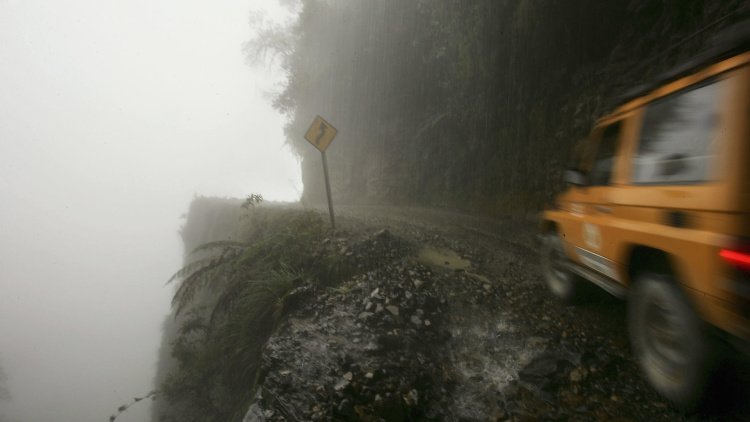
Road of Death - Yungas, Bolivia

Referred to as the World's Most Dangerous Road (WMDR) by the Inter-American Development Bank, the Yungas road is a narrow dirt track which descends nearly 11,800 feet in just 40 miles. There aren't many roads connecting the rainforest areas of Bolivia to the heavily populated capitol. With no other options currently available, vehicles are forced to drive it, resulting in hundreds of annual deaths as trucks, buses and passenger cars fall down to the bare jagged rock below. Fog, sudden rainstorms and landslides are common here. In 2006 it was estimated that accidental deaths totaled between 200 and 300 people. Bolivia is also the poorest nation in South America, so don't expect any new roadways or improvements anytime soon.

The James W. Dalton Highway in Alaska seems to stretch to the very ends of the earth. It was built along side the Trans-Alaskan pipeline for easy service and was not meant for thru traffic, though adventurers still make the trek. The road reaches nearly to the Arctic Ocean. It's mostly dirt, and poorly maintained dirt at that. Still, 150-250 trucks use the road every day. It's actually safer in the winter, when the road is a frozen block of ice. Summer months turn Dalton into a quagmire of mud and it often floods in warmer weather. Truckers have nicknames for different sections of the road, such as 'Oh Shit Corner' and 'The Rollercoaster'. The road really is only suitable for big rigs, as they can weather the harsh winds and storms that seem to blow in from no where. If you do attempt the Dalton Highway The Bureau of Land Management suggests you bring two full tires on rims, survival supplies and a CB radio. The only three towns near the highway have a population of only 57, so if you need help it might be a long time coming. Remember to keep your lights on and don't expect the truckers to stop. Noirmoutier Island in Ile de Noirmoutier, France on October 17th, 2005.
Passage of the Gois - Ile de Noirmoutier, France

Now you see it, now you don't. The Passage of the Gois is a paved sandbar and only road that connects the stunning ancient island of Île de Noirmoutier to the coast of France. It's only passable 1 ½ hours before the lowest tide and a 1 ½ hour afterwards, though daredevils try to traverse this spit of land in less favorable conditions. The ocean has dragged more than one car down to a watery grave. At high tide, this road lies under 1.30 meters to 4 meters of water. When it remerges is is slippery, wet and covered in seaweeds. Drivers are urged to check tide times before attempting to cross the passage and to drive slowly and carefully.
Commonwealth Avenue - Quezon City, Philippines

Welcome to Quezon City, one of the most populous cities in the Philippines and one of the municipalities that make up greater Manilla, the nation's capitol. This 'Killer Highway' is the widest in the country, expanding from six to ten lanes along its stretch. It's also incredibly dangerous, despite not being perched on a high mountain top or near the ocean. That's because almost no traffic laws are enforced on the road. Daily commutes become a tangled, congested mess as drivers make it up as they go along. There are few signs and no street lights. The road is poorly maintained and pedestrians tend to wander in and out of traffic. Public transportation also stops randomly to pick up anyone who flags them down. During the rainy season, a lack of drainage turns Commonwealth Ave. into a raging river. This combo of chaos and congestion makes it extremely dangerous. Three to five crashes happen here every day.
Highway 1 Kabul to Jalalabad, Afganistan
You'd think traveling through Taliban-controlled rural Afghanistan would be dangerous enough; try doing it on a road where fatal crashes are a daily occurrence.
Highway 1 loops through the whole country, but the most dangerous part is a 50-mile stretch from Kabul to Jalalabad that climbs 2,000 feet above sea level. So many people die that locals long ago stopped counting.
The deaths are attributed to a combination of the narrow, winding lanes that climb up through the Kabul gorge and the reckless Afghan drivers used to the hustle and bustle of city streets trying to overtake overloaded trucks.
BR-116 - Brazil

Known as the 'highway of death', the BR-116 is the second longest highway in Brazil. It runs 2,725 miles up the coast. At any given time 60 percent of all traffic on the BR-116 is from semi-trucks, making it the highest concentration of big rigs in the world. Overworked drivers are known to drink and drive, use other drugs or fall asleep at the wheel. Poor maintenance, crooked traffic cops and marauding bands of carjackers also pose unique challenges to travelers. The Sao Paulo-Curitiba section of the highway is perhaps the most dangerous. The road runs along the edges of steep cliffs and one wrong move spells doom for any driver.
Taroko Gorge road - Taiwan

This road winds through some of the most beautiful parts of Taiwan, but don't let the views fool you. The Taroko Gorge road is trickier than it looks. The narrow passage is only suitable for one car or bus to pass through at a time. Meeting on-coming traffic is a game of chicken. Who is going to back up to find a place wide enough to get out of the way? The road is cut out of the mountainsides and offers amazing views of the surrounding national park, but not of the road. Blind curves cause countless front-end collisions between vehicles. The weather is treacherous, as well. Sections may need to be closed quickly due to sudden fog or downpours. Heavy rain can cause landslides and rock falls and the cliff faces easily crumble after earthquakes, a frequent occurrence in this part of the world.
Strada degli Eroi - Verona and Vicenza, Italy

The Strada degli Eroi was built in 1922 to connect towns in Italy through the mountains. This is the only road on this list where motorized traffic is expressly forbidden. Travel on the gravel road was banned after a string of grisly crashes in the 1980s. Tour and shuttle buses do tackle the rugged terrain in the summer to give tourists a glimpse of the stunning scenery. It's called the 'Road of Heroes' and honors 15 soldiers who died in World War I. Ridiculously high up in the mountains, much of the unprotected roads offer the unwary steep drops to the granite valley below. It's now a popular hiking trail, but backpackers should be advised; the weather changes quickly and the area is remote. Stranded hikers can and do get lost in the mists that blanket the road.
Related News